Kronstadt futshtok
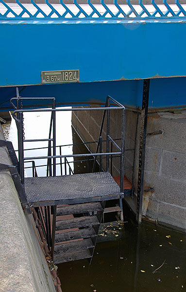
The futshtok service (sea level measurement) in Kronstadt was founded in 1707 and is one of the oldest in the world (the third). The futshtok is a gauge with marks of average water level in the Gulf of Finland. This one was set in 1840 by hydrographer M. Reynike. Mean sea level was set based on the results of observations in 1824-1839 period.
Next photo ->
Home > Kronstadt: city and Kotlin isl.: Main The Town Admirality Marine Museum Italian Palace 18-th arsenal Fort Shanz Fort Riff Lunette Dehn Kosnye batteries Powder magazine of Navy Where is it Plan Links
Land forts and fortress:
Bip Castle Gatchina Ivangorod Izborsk Kexholm Kirillov Monastery Koporye Novgorod Pechorskiy Monastery Peter&Paul Fortress Porkhov Pskov Schlisselburg Staraya Ladoga Tikhvin Vyborg Hameenlinna Hamina Kastelholm Kymenlinna Lappaenranta Raseborg Castle Savonlinna Tavetti Turku Visby Fredrikstadt Fredriksten Hegra Fort Hoytorp Fort Arensburg Narva Tallinn Antipatris Caesarea Jerusalem Latrun Fort Masada
Sea forts and fortresses:
Alexander Fort Ino Fort Krasnaya Gorka Fort Kronstadt: city and Kotlin isl. Kronstadt: North Forts Kronstadt: South Forts Trongsund Hanko Svartholm Sveaborg Marstrand Siaro Fort Vaxholm Oscarsborg
Artillery batteries and individual guns:
Hemso Fort
Fortified areas and defensive lines:
Karelian Fortified Area (KaUR) KrUR Leningrad Mannerheim Line Nevsky Bridgehead VT Line Harparskog Line Mikkeli Salpa Line Gothland
Russian
S e a r c h All news
©2026 Goss.Ru